Updated Mapping for Wollondilly Flood Study
Find Out About Flood Risk in Your Area
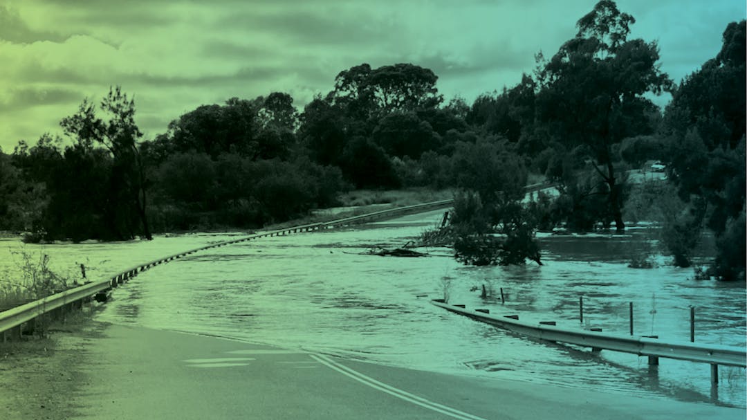
It’s more important than ever to be aware of flood risks where you live.
Wollondilly Shire Council is continuing work on flood mapping across the Shire and checking in with the community again to verify that our modelling reflects lived experience.
Thank you to everyone who has provided input in the previous two rounds of consultation – it has helped in verifying our mapping. We are inviting further feedback until 10 June 2024.
Updates to the Broad Scale Mapping
The broad scale study ranges from Warragamba and Silverdale to Yanderra, and from Nattai to Appin, and uses the latest topographic data and modelling techniques as well as local knowledge in an effort to better understand the nature and extent of flooding across Wollondilly Shire.
We are now inviting additional feedback on the broad scale study that was previously publicly exhibited – it has been updated, with:
- New Probable Maximum Flood (PMF) mapping to show the biggest possible flood
- New Flood Planning Area (FPA) mapping based on 1% Annual Exceedance Probability (AEP) flood, which is classed as very large and has a 1% chance of occurring in any given year
- Distinction between Flood Planning Areas for Overland (Flash) Flooding and Mainstream (Riverine) Flooding.
Detailed Mapping in Villages and Towns
We have also taken a detailed look at specific villages and will have new versions of more precise flood mapping for Appin, The Oaks, Tahmoor, Thirlmere, South Picton, Warragamba, Silverdale, Bargo and Yanderra. This mapping:
- Is more detailed than the broad scale mapping
- Sets us up well for considering Flood Risk Management options.
What is the Flood Risk in Your Area?
Find out what our draft flood mapping says about where you live, and let us know if it matches where you’ve seen and heard about flooding and water flow in your area. You can view flood mapping for the 1 in 10 chance flooding, 1 in 100 chance flooding, 1 in 500 chance flooding, and the Probable Maximum Flood.
- Use the Map Link to our IntraMaps and follow the handy how-to guide
- Take a look at the draft Flood Study at Council’s Customer Service Centre or Wollondilly Library in Picton.
Find Out More & Share Your Thoughts
- Provide feedback on our online feedback form
- Drop a pin on the mapping tool below, with comments and a photo
- Send an email to council@wollondilly.nsw.gov.au quoting CM 10505
- Call us on 4677 1100
- Join us at a drop-in session to find out more about the flood mapping, ask questions, and provide feedback about what the mapping shows.
- Wednesday 8 May at Tahmoor Sporting Complex from 4:00-7:00pm
- Thursday 9 May at The Oaks Community Hall from 4:00-7:00pm
- Saturday 11 May at Tahmoor Sporting Complex from 9:00am-12:00pm
- Wednesday 15 May at Yanderra Public School from 4:00-7:00pm
- Monday 20 May at Appin AIS Community Hall from 4:00-7:00pm
- Wednesday 29 May at Warragamba Town Hall (Seniors Annex) from 4:00-7:00pm
- Thursday 30 May at Douglas Park Community Centre from 4:00-7:00pm
- Wednesday 5 June at Bargo Community Hall from 12:00-3:00pm
How You Can Help
We are looking for input such as:
- Photos or video
- Recorded high water marks
- Where water flows in your neighbourhood during storms
- Your feedback about our updated draft mapping.
Understanding Risk Helps Manage Risk
The process of doing a flood study helps Council and the community understand flood risk. It’s important to note that the study assesses existing flood risk. It doesn’t change a property’s flood risk – it evaluates existing risk.
All Councils in NSW are undertaking flood studies and flood risk management plans to fulfil NSW Government requirements under the NSW Flood Prone Land Policy. Council has engaged consultants Worley Consulting (previously called Advisian) to carry out the Flood Study.
Thank you to everyone who provided input regarding Stonequarry Creek. The new updated draft Wollondilly Flood Study builds on the adopted Stonequarry Creek Floodplain Risk Management Plan, and the range of actions now underway or already delivered to help address flooding for Picton.
Consultation Closes
We are accepting feedback until 5:00pm on Monday 10 June 2024. For more information please contact Council on 4677 1100.

